Ergin C. Cankaya
👋 Ergin C. Cankaya
Forest Data Scientist | LiDAR Specialist | Remote Sensing Researcher
PhD Candidate @ University of Alberta | Forest Growth Modelling • LiDAR • Remote Sensing • RShiny
🌟 Featured Project
🚀 National Forest Inventory Decision Support System (UOE DSS)
📍 Developed using RShiny, Leaflet, Plotly, and Docker
☁️ Hosted on Microsoft Azure
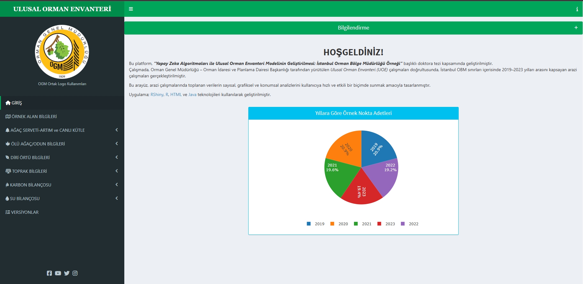
This interactive platform visualizes and analyzes spatial and tabular data from Turkey’s National Forest Inventory (UOE). It integrates diverse datasets — including tree metrics, biomass, understory, soil, and carbon — into an accessible decision support tool for forest managers, researchers, and policy-makers.
🎯 Research Interests
- 🌲 Forest Growth Models (Allometry, Yield Forecasting)
- 🚁 LiDAR & Photogrammetry (UAV, Handheld, Terrestrial Systems)
- 🛰️ Remote Sensing & GIS (Time-Series Analysis, Tree Species Classification)
- 🤖 AI for Forestry (Random Forest, Deep Learning, Forest Inventory Automation)
🏆 Highlights
| Year | Activity |
|---|---|
| 2025 | 🏅 Awarded NSERC Doctoral Fellowship |
| 2025 | 🌍 Released: UOE RShiny Dashboard for the National Forest Inventory in Turkey |
| 2023 | 🏅 Best Poster Presentation Award at the 93rd Forest Industry Lecture Series (FILS) |
| 2023 | 🗣 Oral Presentation: ISCL: Individual Tree Detection from UAV LiDAR, Québec, Canada |
📚 Selected Publications
- Çankaya, E. Ç. (2021). Using handheld mobile LiDAR technology in forest inventories: A case study from Artvin-Şavşat. Forestry Research Journal, Dec 11, 2021.
- Copenheaver, C. A., et al., Çankaya, E. Ç. (2017). Dendroarchaeology of Appalachian Forests. Poster presented at IUFRO.
- Çankaya, E. Ç. (2015). Forest Road Network Effect on Forest Fire: A Case Study of Turkey. COFE, Lexington, KY.
- Çankaya, E. Ç. (2015). Evaluating Forest-Based Land Use Change Trends Using CA-Markov. COFE, Lexington, KY.
💼 Experience & Teaching
University of Alberta – PhD Researcher
📍 Edmonton, AB · 2021 – Present
- Forest growth & yield modeling using LiDAR-derived inventory data
- Development of RShiny dashboards for forest decision support systems
General Directorate of Forestry (OGM) – Remote Sensing Analyst
📍 Ankara, Turkey · 2018 – 2025
- LiDAR & multispectral data processing for operational forest inventory
- Spatial modeling & web-based reporting tools for forest management
Teaching Assistant – University of Alberta
- REN R 260 – Environmental Protection & Conservation (2025)
- REN R 350 – Physical Hydrology (2025)
- REN R 201 – Geomatic Techniques (2024)
- REN R 215 – Forest Measurements (2024)
- REN R 295 – Field Skills in Forest Science (2023)
🛠️ Technical Skills
![]()
![]()
![]()
![]()
![]()
📊 GitHub Stats
✉️ Get in Touch
- 📧 ergin@ualberta.ca
- 🌐 Personal Website
- 📄 Download CV (PDF)
_“Nearly all my work is open source—feel free to explore and contribute!”_